Our mapping and surveying services capture high-resolution aerial data across your entire site in a fraction of the time traditional ground surveys require. We deliver orthorectified maps, topographic data, and property boundary documentation that land developers, engineers, and municipalities in Victoria can act on immediately.
Our measurements and analytics services turn raw aerial data into precise calculations. Volume measurements for stockpiles, cut-and-fill analysis for grading projects, acreage calculations for farmland - we extract the numbers that matter and deliver them in formats your team already uses. Victoria's agriculture and energy sectors depend on accurate data, and we give you exactly that.
Our inspection and monitoring services put a camera where it is dangerous or impossible to send a person. We inspect rooftops, communication towers, pipeline infrastructure, storage tanks, and industrial equipment throughout the Victoria area. Detailed visual reports help you spot problems before they become shutdowns.
Our 3D and digital modeling services convert aerial imagery into point clouds, mesh models, and digital twins of your site or structure. Architects, engineers, and project managers in Victoria use these models to plan, review, and communicate project status without stepping foot on-site.
Our creative and marketing services deliver cinematic aerial footage and photography that showcases your property, project, or business from above. Real estate listings, development marketing materials, and commercial brand content all benefit from the kind of perspective only a drone can provide. Victoria businesses use our footage to stand out in a competitive market.
Reach out by phone or through our website. We ask a few questions about your site, timeline, and deliverable needs to scope the job correctly.
Our team checks airspace authorizations, site access, and any local restrictions around your Victoria location. We handle the FAA coordination so you do not have to.
On flight day, our certified pilots collect data with precision. We follow a structured flight plan built around your project goals - coverage area, resolution, and capture angle are all set before we leave the ground.
Raw imagery goes through our processing pipeline to produce maps, models, measurements, or inspection reports depending on your order. We check every deliverable for accuracy before it leaves our hands.
You receive your data through a secure link. For complex deliverables like 3D models or full inspection reports, we schedule a brief review call so you can ask questions and put the data to work right away.
We work across agriculture, oil and gas, construction, real estate, and industrial manufacturing. In Victoria specifically, a large share of our clients are row-crop and ranch operations, pipeline and energy infrastructure owners, and commercial construction firms. If your project involves land, structures, or infrastructure, we likely have experience with something similar.
Small sites under 50 acres typically fly in one to two hours. Larger properties or more complex projects like full inspections or multi-structure facilities take longer. We give you a realistic time estimate during project scoping so your team can plan around our visit.
Most projects turn around in 24 to 72 hours. Basic orthomosaic maps and aerial photos often come back the same day or next morning. Complex deliverables like 3D models and detailed inspection reports take a bit longer due to processing time. We confirm the expected delivery window before every job.
Not much. If your site has any access restrictions or gates, we will need entry information ahead of time. For large or complex sites, walking us through any areas of concern before flight day helps us prioritize the right coverage. We handle all FAA airspace coordination and clearance – that is our responsibility, not yours.
It depends on the service. Mapping projects typically deliver GeoTIFF orthomosaics and digital elevation models. Point clouds come in LAS or LAZ. 3D models come in OBJ or other industry-standard formats. Inspection reports come as PDFs with annotated imagery. Aerial video comes in MP4 at broadcast-quality resolution. If your team uses specific software, tell us upfront and we will format deliverables to match.
Yes, with proper coordination. Industrial sites have specific safety and access requirements. We work directly with your facility team to understand those requirements, clear necessary airspace, and fly within your safety protocols. We carry full liability coverage for every commercial flight.
We capture imagery at sub-inch resolution for close-range inspection work and typically 1 to 3 centimeter per pixel ground resolution for mapping projects. The resolution we target depends on your project requirements. Higher resolution means more passes and longer flight time – we match the resolution to what your deliverable actually needs.
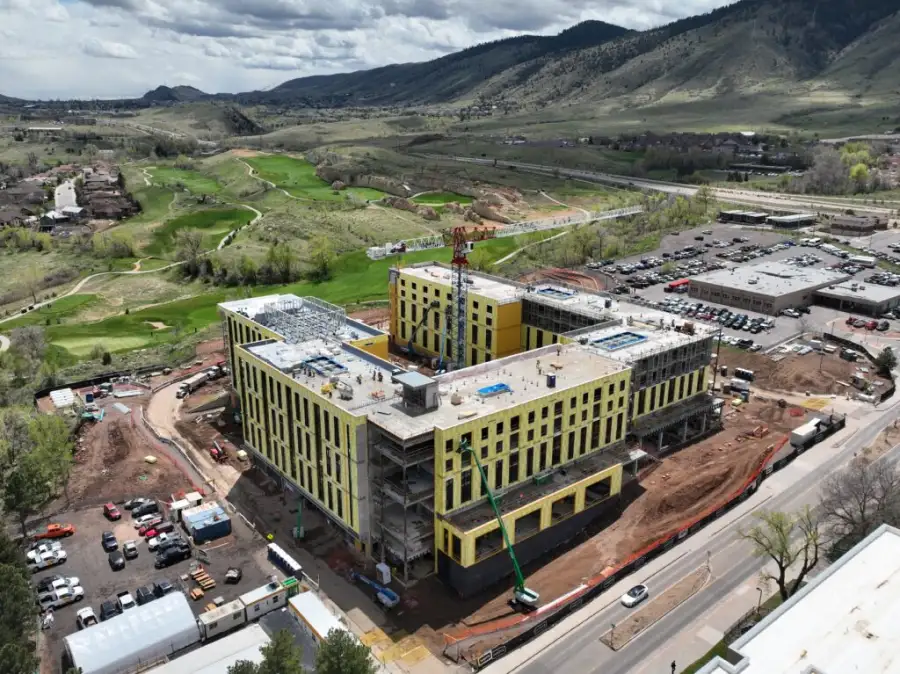
Yes. Progress monitoring is one of the most common requests we get from construction and development projects. We schedule recurring flights, process the data consistently, and deliver reports that let you compare conditions across dates. This is especially useful for tracking grading, earthwork, and construction milestones.
We reschedule at no penalty. High winds, rain, or low visibility can affect data quality, so we do not fly under those conditions. We stay in contact with you leading up to the flight day and notify you as early as possible if conditions require a change.
Yes. Victoria County has a large number of row-crop and cattle operations. We provide crop health mapping using multispectral imagery, field boundary mapping, drainage analysis, and infrastructure inspection for irrigation systems and outbuildings. Farmers and ranch managers use this data to find problems early and manage their land more efficiently.
Mapping captures data across a wide area to produce survey-grade outputs like orthorectified maps, elevation data, and volumetric calculations. Inspection focuses on getting close-up, high-detail imagery of a specific structure or piece of equipment – tanks, towers, rooftops, pipelines. Both use drones, but the flight approach, sensors, and deliverables are different. We help you figure out which service fits your project during the initial consultation.
Yes. Our creative and marketing services are built specifically for that use case. Real estate listings, commercial property marketing, agricultural land sales, and development announcements all benefit from aerial photography and video. We deliver footage in broadcast quality and can format it for web, social media, or print use.