

South Texas sits at the center of one of the most active oil and gas regions in the country. The Eagle Ford Shale, Permian Basin pipeline corridors, and the Port of Corpus Christi’s refining and export infrastructure put real pressure on operators to inspect assets faster, document conditions more accurately, and maintain compliance records that hold up under TCEQ and EPA review.
That pressure compounds quickly. Upstream teams need wellpad surveys during active drilling campaigns. Midstream operators manage hundreds of miles of pipeline through remote terrain. Downstream facilities require regular inspection of tanks, flare stacks, and processing equipment where manual access is slow, expensive, and sometimes impossible.
Skyline Drone Mapping (SDM) delivers aerial mapping, LiDAR, visual and thermal inspections, methane detection, emissions mapping, measurement, and digital asset documentation built for the pace and precision of oil and gas operations. Our deliverables support engineering, asset integrity, GIS, HSE, LDAR, environmental, and operations teams with traceable, georeferenced records that integrate into existing workflows while reducing personnel exposure and operational disruption.

| Service | Expanded Deliverables | Outputs | Why It Matters |
|---|---|---|---|
| Orthomosaic Mapping (2D) | RTK/PPK-enabled orthomosaics for wellpads, facilities, tank farms, terminals, construction areas, and pipeline rights-of-way | GeoTIFF, KML/KMZ, web viewer | Accurate basemaps for planning, coordination, documentation, and GIS integration |
| Topographic Mapping (DSM/DTM) | Terrain surfaces, contours, drainage information, and elevation data for wellpad development, facility expansion, access roads, reclamation, and earthwork planning | DSM, DTM, contours, DXF, SHP, GeoTIFF | Supports grading, drainage, earthwork, access, and site-development workflows |
| Drone Surveying & Photogrammetry | Control-tied mapping, surface models, planimetric information, and georeferenced datasets supporting survey, engineering, GIS, and construction teams | CAD/GIS-ready datasets | Rapid site intelligence that complements licensed survey and engineering workflows |
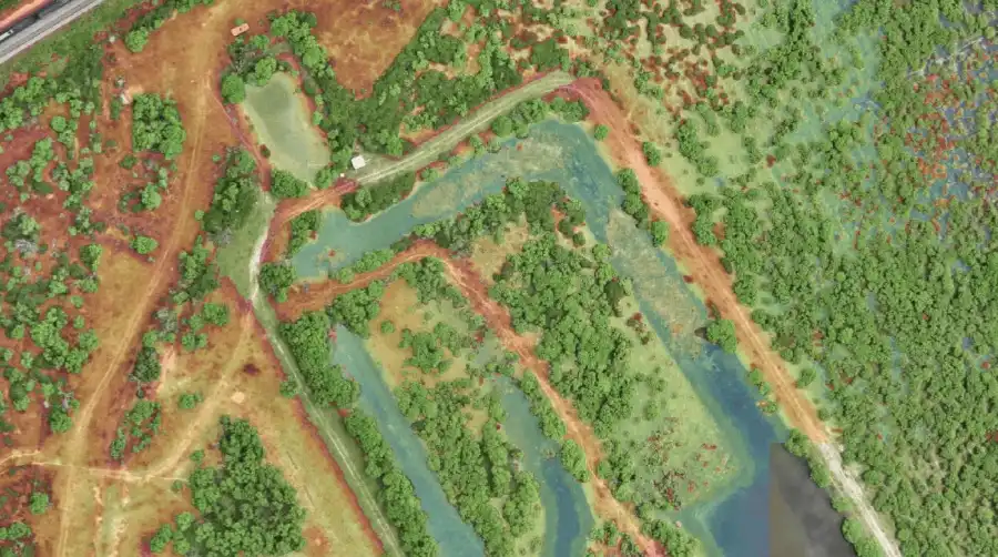
| LiDAR Mapping | Dense point clouds, terrain extraction, corridor mapping, and 3D asset documentation across pipeline rights-of-way, vegetated areas, facility expansions, drainage corridors, and complex aboveground infrastructure | LAS/LAZ, DSM, DTM, contours, DXF, SHP, point clouds | Provides reliable terrain and asset data in vegetated, remote, or geometrically complex environments |
| Service | Expanded Deliverables | Outputs | Why It Matters |
|---|---|---|---|
| Volumetrics & Earthwork Measurement | Cut/fill analysis and volumes for pad construction and reclamation | CSV, PDF, DXF | Defensible quantities for cost control and pay applications |
| ROW Corridor Metrics | Distance, clearance, and encroachment measurements along pipeline routes | CSV, GIS layers | Vegetation management and corridor compliance data |
| Recurring Monitoring & Change Detection | Repeatable capture and comparison of facilities, pads, corridors, construction areas, reclamation sites, and incident locations | Comparison maps, change layers, annotated imagery, GIS layers, PDF reports, web viewer | Creates a traceable condition history and helps teams identify physical, environmental, or operational changes between inspection cycles |
| Service | Expanded Deliverables | Outputs | Why It Matters |
|---|---|---|---|
| Aerial Asset Inspections | High-resolution visual inspections of tanks, flare stacks, pipelines, compressor stations, pipe racks, processing equipment, and facility infrastructure | Photos, video, annotated imagery, finding logs, PDF reports | Provides safer access to elevated, hazardous, remote, or difficult-to-reach assets while supporting maintenance planning |
| Radiometric Thermal Inspections | Heat-pattern analysis of electrical equipment, insulation systems, flare and combustion conditions, tank thermal patterns, mechanical components, and other temperature-related anomalies | Radiometric imagery, annotated findings, MP4, PDF reports | Supports condition-based maintenance and early investigation of abnormal heat patterns |
| Optical Gas Imaging (OGI) | Specialized infrared visualization and documentation of methane or VOC emissions where detectable under site and environmental conditions | OGI video, annotated clips and stills, geotagged finding logs, KML/KMZ, PDF reports | Supports leak localization, repair prioritization, LDAR workflows, and emissions documentation |
| Methane Plume Mapping & Quantification Support | Drone-mounted remote methane screening, 2D/3D plume visualization, source localization, and quantification support across facilities, pipelines, and suspected emission areas | Plume maps, concentration-path data, KML/KMZ, CSV, PDF, web visualization | Rapidly screens large or complex sites and helps teams prioritize closer investigation and repair |
| Multi-Gas Concentration Mapping | In-situ concentration measurements and hyperlocal 2D/3D mapping of configured gases around facilities, suspected sources, and incident areas | Concentration maps, CSV, KML/KMZ, georeferenced flight data, PDF reports | Adds gas-specific measurements and spatial context for verification, environmental monitoring, and incident response |
| Service | Expanded Deliverables | Outputs | Why It Matters |
|---|---|---|---|
| 3D Facility Models | High-resolution 3D models and point clouds of processing facilities, tank farms, terminals, compressor stations, wellpads, and aboveground infrastructure | LAS/LAZ, OBJ, glTF, textured mesh, point cloud, secure web viewer | Improves planning, remote review, measurement, coordination, and stakeholder visibility |
| Oil & Gas Asset Digital Twins | Measurable, time-based facility and site models that connect baseline conditions, inspection annotations, thermal findings, gas-detection layers, OGI clips, documents, maintenance records, and recurring comparisons | Secure web viewer, annotations, linked media and documents, measurements, GIS layers, inspection history, and time-based comparisons | Creates a shared source of truth for operations, integrity, maintenance, environmental review, incident analysis, planning, and decommissioning |
| Service | Expanded Deliverables | Outputs | Why It Matters |
|---|---|---|---|
| Aerial Photo & Video | Site documentation for operations, compliance, and investor reporting | MP4, JPG | Visual record of conditions at a specific point in time |
| FPV Fly-Throughs | Immersive walkthroughs of facilities and infrastructure | MP4 | Training, planning, and stakeholder communication |
| Lifecycle Stage | SDM Value |
|---|---|
| Exploration & Site Selection | Basemaps, topo surfaces, and terrain analysis for pad site evaluation. |
| Pre-Construction (Wellpad) | Topographic mapping, earthwork support, and baseline site documentation. |
| Active Production & Operations | Facility mapping, visual and thermal inspections, methane screening, gas concentration mapping, tank and equipment documentation, and recurring site monitoring. |
| Asset Integrity & Maintenance | Pipeline and facility inspections, thermal condition monitoring, change detection, OGI documentation, digital-twin annotations, and recurring condition records. |
| Environmental & Regulatory Compliance | OGI documentation, methane plume mapping, multi-gas concentration mapping, spill and incident documentation, GIS-ready findings, and traceable inspection records supporting operator programs. |
| Incident & Emergency Response | Rapid visual, thermal, methane, and multi-gas situational mapping; plume and site-condition documentation; georeferenced findings; and shared digital-twin or web-viewer access for response teams. |
| Decommissioning & Reclamation | Pre-closure baselines, infrastructure documentation, volumetrics, terrain models, environmental condition records, removal progress, and before-and-after comparisons. |